The Driftless Area is a region in Minnesota, Wisconsin, northwestern Illinois, and northeastern Iowa of the American Midwest that was never glaciated.
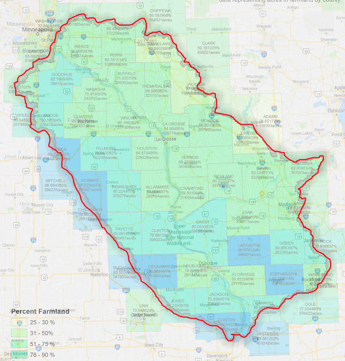
 The region includes elevations ranging from 603 to 1,719 feet at Blue Mound State Park and covers an area of 24,000 square miles with over 3 million people. (See census info below)
The rugged terrain is due both to the lack of glacial deposits, or drift, and to the incision of the upper Mississippi River and its tributaries into bedrock.
Geology
Karst topography is found throughout the Driftless area. This is characterized by caves and cave systems, disappearing streams, blind valleys, underground streams, sinkholes, springs, and cold streams. Disappearing streams occur where surface waters sinks down into the earth through fractured bedrock or a sinkhole, either joining an aquifer, or becoming an underground stream. Blind valleys are formed by disappearing streams and lack an outlet to any other stream. Sinkholes are the result of the collapse of the roof of a cave, and surface water can flow directly into them. Disappearing streams can re-emerge as large cold springs. Cold streams with cold springs as their sources are noted as superb trout habitats.
Rivers
The Mississippi River passes through the Driftless Area. As rivers and streams approach their confluence with the Mississippi, their canyons grow progressively steeper and deeper, particularly in the last 25 miles in their journey to their mouths.
There are many small towns in the Driftless Area, especially in river valleys, at or upstream from the Mississippi. Small towns in a deep steep valley going down to the Mississippi are at risk every 50 to 100 years or so of a major flood, as with the wreck of Gays Mills, Wisconsin, in August 2007, or the holding of the levee in Houston, Minnesota, (on the South Fork Root River) at the same time. Metropolitan areas have flood walls for protection.
Other rivers affected by this geologic process are:
In Wisconsin: the Chippewa, Trempealeau, La Crosse, Black, Pecatonica, and Wisconsin Rivers, along with the Wisconsin River’s tributary, the Kickapoo River;
In Minnesota: the Whitewater, Cannon, Zumbro, and Root rivers;
In Iowa: the Upper Iowa (and Paint Creek), Yellow, Turkey, and Maquoketa rivers;
In Illinois: the Apple River and the Galena River (a.k.a. the Fever River).
The Saint Croix in Minnesota and Wisconsin is another important river in the Driftless Area, as it was the outlet for Glacial Lake Duluth, forerunner to Lake Superior, when the eastern outlet was blocked by the continental ice sheet. These rivers all have deep, dramatic canyons giving testimony to the immense quantity of water which once surged through them. The Wisconsin River drained Glacial Lake Wisconsin. Glacial River Warren, whose bed is now occupied by the Minnesota River, drained the colossal Glacial Lake Agassiz. There was ample water to dig a very deep, hundreds-of-miles-long gash into the North American bedrock.
Ecosystem
The climate is humid continental, displaying both the cool summer and warm summer subtypes as one travels from north to south. The winters in certian regions of the Driftless can be quite severe, with the Mississippi freezing over.
Prior to European settlement in the 19th century, the vegetation consisted of tallgrass prairie and bur oak savanna on ridgetops and dry upper slopes, sugar maple-basswood-oak forest on moister slopes, sugar maple-basswood forests in protected valleys and on north-facing slopes, wet prairies along the rivers and some mesic prairie on the floodplain farther back from the river. There were probably also oak forests that contained no sugar maple. Marsh and floodplain forests were also common on river flood plains. Prairie was restricted primarily to the broader ridge tops, which were unfavorable sites for trees due to thin soils and shallow bedrock, rapid drainage, and desiccating winds; all these conditions were also good for carrying fires across the landscape. Prairies also occurred on steep slopes with south or southwest aspect. Natural fire, which has long been vigorously suppressed, was essential for the regeneration of such prairies.
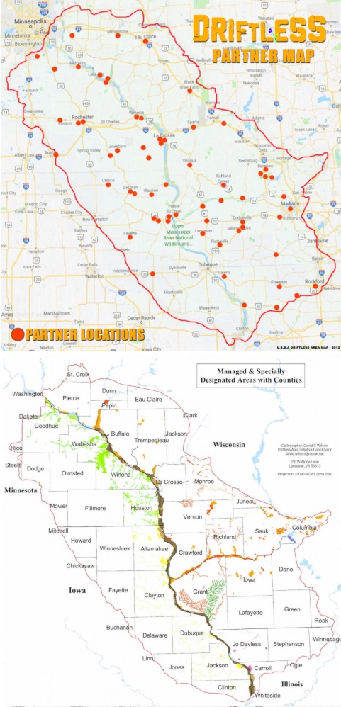
The Midwest Driftless Area Restoration Effort is a multi-agency cooperative effort to restore the landscape. The main issues are water pollution from agricultural and animal runoff, and erosion. Water pollution is particularly critical in karsted regions such as this, in that it can degrade or destroy prime cold water fish habitat. Soil erosion presents the Army Corps of Engineers with a particular problem, in that it requires them to dredge the Mississippi River shipping channels to keep them open. Trout Unlimited is part of this effort, if only because of the superb cold-water streams the region supports. A symposium was held in October 2007 in Decorah, Iowa, “to share the results of research, management and monitoring work in the Driftless Area.” The Nature Conservancy is also interested.
The Driftless Area contains more than half of the world’s algific talus slopes, a type of small, isolated ecosystem. These refugia create cool summer and fall microclimates which host species usually found further north. They contain at least one endangered species, the Iowa Pleistocene Snail, and a threatened plant, the Northern monkshood. The Driftless Area National Wildlife Refuge was primarily carved out of the Upper Mississippi River National Wildlife and Fish Refuge in order to protect these species and their associated ecosystems.
A particularly noteworthy annual event is the rising of fishflies, a kind of mayfly endemic to the Mississippi valley in the region. These are aquatic insects attracted to light, which rise by the millions as adults to mate, only to die within hours.
Wildlife is abundant with opportunities for hunting whitetail deer and wild turkey. Fishing, particularly for brown trout, brook trout and rainbow trout in tributaries, and species such as channel catfish in the Mississippi is available, with ice fishing in winter.
Other characteristics
A modern, man-made characteristic is the comparatively twisty nature of highways in the region. The route of U.S. Highway 20 through the Driftless, and particularly in Illinois, is a good example.
The bioregion shares economic and cultural characteristics, as well. These were federally recognized with the granting of the Upper Mississippi River Valley viticultural area by the Treasury Division’s Tax and Trade Bureau in 2009. The UMRV is the largest designated winemaking region in the country. The petition for designation includes a 16-page narrative that spells out why this region is a cohesive whole for marketing wine, and is now used to market other products.
At the University of Wisconsin-Madison, the Center for Integrated Agricultural System’s Food and Farm project is working with the region’s sustainable-agriculture farmers, processors, distributors, chefs, planning commissions, and others to define the culinary identity of the region and direct the development of agrotourism. For instance, 75% of the raw-milk artisan cheese produced in Wisconsin is made in the Driftless region. This cheese is made from milk produced by cows that graze on pastures. The region is home to Organic Valley, the nation’s largest organic dairy cooperative. Generally, organic dairy production fits best with a grass-based milk production system. In addition to winegrape production and wine-making, the region also is known for apple production, and a number of hard cider makers are about to hit the market with product. The region is historically known for grass-fed beef, and has great potential to market forest botanicals – especially mushrooms – to the 21 million people in the region, including the relatively nearby Minneapolis-St. Paul, Chicago, and Milwaukee markets.
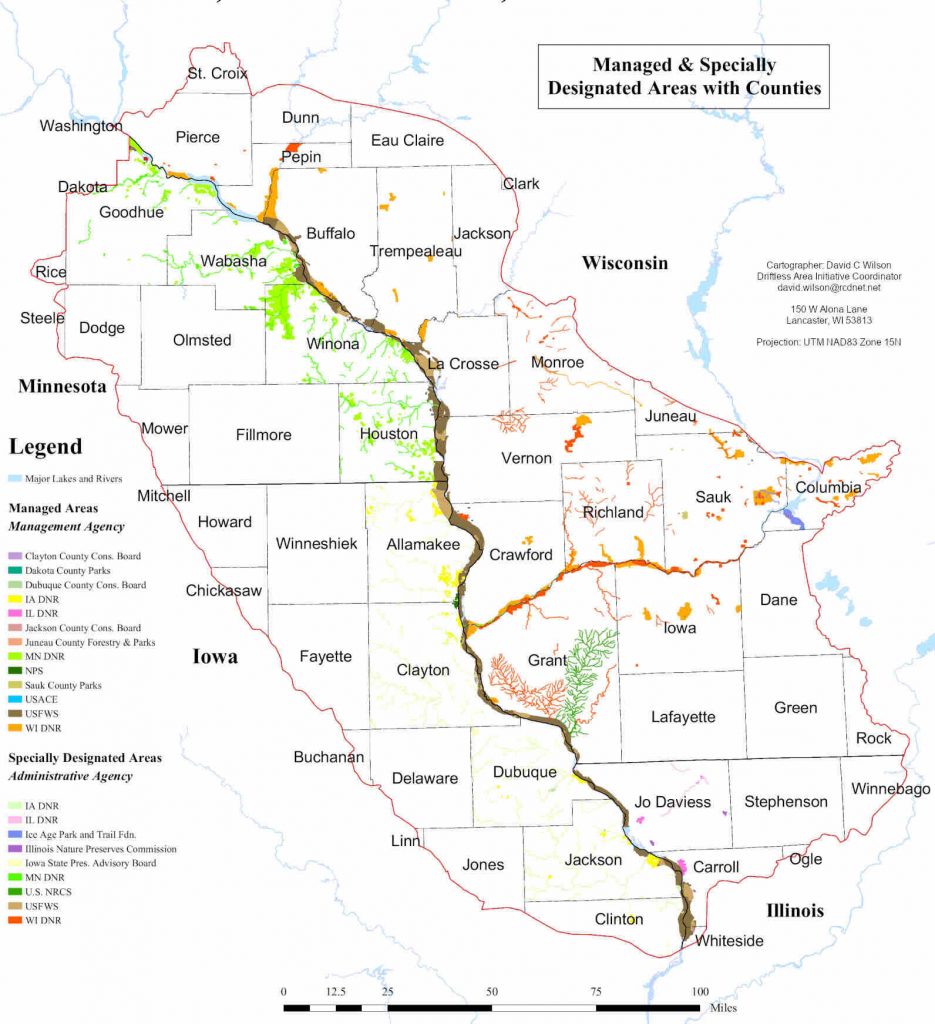
Managed & Specially Designated Areas with Counties – Detailed View
POPULATION BY COUNTY | 2020-21 CENSUS | ALL STATES = 3,822,810
| Wisconsin Pierce 42,212 Pepin 7,318 Eau Claire 105,710 Buffalo 13,317 Trempealeau 30,760 Jackson 21,145 La Crosse 120,784 Monroe 46,274 Juneau 26,718 Vernon 30,714 Richland 17,304 Sauk 65,763 Crawford 16,113 Iowa 23,709 Dane 561,504 Green 37,093 Grant 51,938 Lafayette 16,611 Adams 20,654 Wood 74,207 Portage 70,377 Rock 164,381 Columbia 58,488 St Croix 95,044 Dunn 45,547 Clark 34,746 Chippewa 66,865 |
Minnesota Dakota 443,341 Goodhue 47,582 Rice 67,097 Wabasha 21,387 Winona 49,671 Olmsted 162,847 Dodge 20,867 Houston 18,843 Fillmore 21,228 Mower 40,029 Rochester + Rural 226,329 Red Wing 16,547 Steele 37,349 |
Iowa Allamakee 14,061 Clayton 17,043 Fayette 19,509 Delaware 17,488 Winneshiek 20,070 Howard 9,469 Dubuque 99,266 Jackson 19,485 Mitchell 10,555 Chickasaw 11,887 Buchanan 20,657 Jones 20,805 Clinton 46,463 Linn 228,939 |
Illinois Jo Daviess 22,035 Carroll 15,702 Whiteside 55,691 Stephenson 44,021 Ogle 51,449 Winnebago 2,903 Clinton 36,899 |