Fort Snelling – St. Paul, MN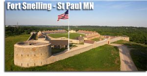
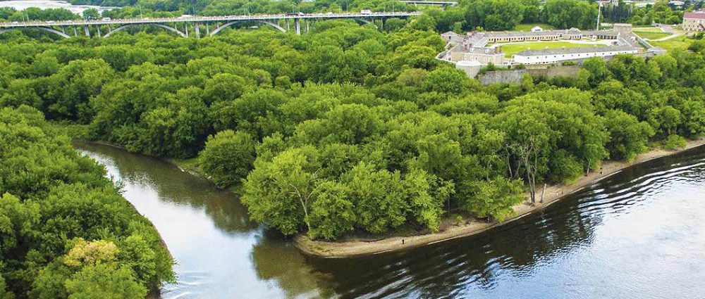
Fort Snelling, originally known as Fort Saint Anthony, is a United States military fortification located at the confluence of the Minnesota and Mississippi rivers in Hennepin County, Minnesota. The Mississippi National River and Recreation Area, a National Park Service unit, includes historic Fort Snelling.
The fort is located in Fort Snelling Unorganized Territory in Hennepin County, Minnesota, named after the fortification. The Minnesota Historical Society now runs the fort, located atop a bluff along the river. The Minnesota Department of Natural Resources runs Fort Snelling State Park, protecting the land at the bottom of the bluff. Fort Snelling once encompassed both parcels.
The fort is designated as a National Historic Landmark and has been named a “national treasure” by the National Trust for Historic Preservation.
Minneapolis–Saint Paul
Minneapolis–Saint Paul is a major metropolitan area built around the Mississippi, Minnesota and St. Croix rivers in east central Minnesota. The area is commonly known as the Twin Cities after its two largest cities, Minneapolis, the most populous city in the state, and Saint Paul, the state capital. It is an example of twin cities in the sense of geographical proximity. Minnesotans living outside of Minneapolis and Saint Paul often refer to the two together (or the seven-county metro area collectively) as “The Cities”.
There are several different definitions of the region. Many refer to the Twin Cities as the seven-county region which is governed under the Metropolitan Council regional governmental agency and planning organization. The Office of Management and Budget officially designates 16 counties as the “Minneapolis–St. Paul–Bloomington MN–WI Metropolitan Statistical Area”, the 16th largest in the United States. The entire region known as the “Minneapolis–St. Paul MN–WI Combined Statistical Area”, has a population of 3,946,533, the 14th largest, according to 2017 Census estimates.
Despite the Twin moniker, both cities are independent municipalities with defined borders. Minneapolis is somewhat younger with more modern skyscrapers downtown, while Saint Paul has been likened to an East Coast city, with quaint neighborhoods and a vast collection of well-preserved late-Victorian architecture.
Minneapolis was influenced by its early Scandinavian and Lutheran heritage. St. Paul was influenced by its early French, Irish and German Catholic roots.
History
The first European settlement in the region was near what is now known as the town of Stillwater, Minnesota. The city is approximately 20 miles (30 km) from downtown Saint Paul and lies on the western bank of the St. Croix River, which forms the border of central Minnesota and Wisconsin. Another settlement that began fueling early interest in the area was the outpost at Fort Snelling, which was constructed from 1820 to 1825 at the confluence of the Minnesota River and the Mississippi River.
Fort Snelling held jurisdiction over the land south of Saint Anthony Falls, thus a town known as Saint Anthony grew just north of the river. For several years, the only European resident to live on the south bank of the river was Colonel John H. Stevens, who operated a ferry service across the river. As soon as the land area controlled by Fort Snelling was reduced, new settlers began flocking across to the new village of Minneapolis. The town grew quickly, and Minneapolis and Saint Anthony eventually merged. On the eastern side of the Mississippi, a few villages such as Pig’s Eye and Lambert’s Landing developed and would soon grow to become Saint Paul.
Natural geography played a role in the settlement and development of the two cities. The Mississippi River Valley in this area is defined by a series of stone bluffs that line both sides of the river. Saint Paul grew up around Lambert’s Landing, the last place to unload boats coming upriver at an easily accessible point, some seven miles (11 km) downstream from Saint Anthony Falls, the geographic feature that, due to the value of its immense water power for industry, defined the location of Minneapolis and its prominence as the Mill City. The falls can be seen today from the Mill City Museum, housed in the former Washburn “A” Mill, which was among the world’s largest mills in its time.
The oldest farms in the state are located in Washington County, the eastern most county on the Minnesota side of the metropolitan area. Joseph Haskell was Minnesota’s first farmer, harvesting the first crops in the state in 1840 on what is now part of Afton Township on Trading Post Trail.
The Grand Excursion, a trip into the Upper Midwest sponsored by the Rock Island Railroad, brought more than a thousand curious travelers into the area by rail and steamboat in 1854. The next year, in 1855, Henry Wadsworth Longfellow published The Song of Hiawatha, an epic poem based on the Ojibwe legends of Hiawatha. A number of natural area landmarks were included in the story, such as Lake Minnetonka and Minnehaha Falls. Tourists inspired by the coverage of the Grand Excursion in eastern newspapers and those who read Longfellow’s story flocked to the area in the following decades.
At one time, the region also had numerous passenger rail services, including both interurban streetcar systems and interstate rail. Due to the width of the river at points further south, the Minneapolis–Saint Paul area was briefly one of the few places where the Mississippi could be crossed by railroad. A great amount of commercial rail traffic also ran through the area, often carrying grain to be processed at mills in Minneapolis or delivering other goods to Saint Paul to be transported along the Mississippi. Saint Paul had long been at the head of navigation on the river, prior to a new lock and dam facility being added upriver in Minneapolis.
Passenger travel hit its peak in 1888 with nearly eight million traversing to and from the Saint Paul Union Depot. This amounted to approximately 150 trains daily. Before long, other rail crossings were built farther south and travel through the region began to decline. In an effort by the rail companies to combat the rise of the automobile, some of the earliest streamliners ran from Chicago to Minneapolis/Saint Paul and eventually served distant points in the Pacific Northwest. Today, the only vestige of this interstate service comes by Amtrak’s Empire Builder train, running once daily in each direction. It is the railroad’s busiest long-distance train and is named after James J. Hill, a railroad tycoon who settled on Summit Avenue in Saint Paul at what is now known as the James J. Hill House.
Like many Northern cities that grew up with the Industrial Revolution, Minneapolis and St. Paul experienced shifts in their economic base as heavy industry declined, especially in the 1960s and 1970s. Along with the economic decline of the 60s and 70s came population decline in the central city areas, white flight to suburbs, and, in the summer of 1967, race riots on Minneapolis’s North Side. By the 1980s and 1990s, however, Minneapolis and St. Paul were frequently cited as former Rust Belt cities that had made successful transitions to service, high-technology, finance, and information economies.
Information provided by WikiMedia Foundation in whole and in part. Link to information can be found here:
https://en.wikipedia.org/wiki/Fort_Snelling
https://en.wikipedia.org/wiki/Minneapolis-Saint_Paul
2021-03-19